
- IDERE HILLS
Idere is very rich in tourism generally. Cultural & historical ranging from our food, dialect, religion, music, man-made wonders, festivals, hills, Valleys, mountains, caves, lakes of different sizes, wonderful rock formations, Eco System and so on The major Tourist Sites that has a good number of Historical collections is IDERE HILLS.
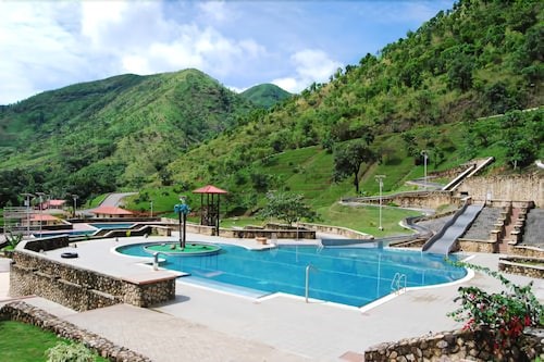
It is situated in Idere town; Ibarapa Central Local Government Oyo State It was once a settlement with an advantage of protection from intruders especially during wars as there are only few entry points to the town on the rock. Two kings (obas) reigned there before relocating the township to the foothill and other places called Idere today. Part of Idere Hills is being used for farming – cocoa, cassava, tomatoes etc but the whole terrain is being planned to become world class tourism and recreational center.
Some of the sites and their historical significances;
Aroye – meaning ‘we can see and understand’. It is a three layered rock formation. It is a post/office for the secret police/spy. Areas in front of ‘Yara’ can easily be seen and findings communicated to the guards and palace for coordination.
Yara – Yara means room in Yoruba language. It is the real main gate to the town on the hills proper. The walls on either side are rocky and approximately about 40ft in length, 18ft in height, and about 6ft apart. It served the trio purpose of security gate with inlet and outlet, room or office for the guards, and the top to the right (Iho Eja) for the snipers.

Eeyore – is the natural water pool on Idere hills. It is a big indentation with water storage capacity of approximately over 12,000L which is sufficient to support the community then even during the dry season. Its water is majorly for household and agricultural purposes.
Olorogun meji – two small lakes believed to have been formed by two female rivals, wives to a particular husband and are both mystical.
Odi Ilu – defense wall, specially formulated and constructed, it has holes for sighting and shooting. It has withstood wind, sun, rain for over 200 years. It is one of the major relics on Idere hills.
Kosomonu – an area on Idere hills, about the tallest place. From here the whole township can be viewed. Kosomonu means, ‘ he does not lose the child’ – if somebody is lost, instead of running aimlessly around, they go to Kosomonu section of the hills, locate the child and send to fetch the child. It has a tunnel that also serves as a hideout – narrower and longer than ‘Yara’.
Iso Eleko Idere – the spot at which the famed Eleko Idere of Irosun meji in IFA panegyrics sold her pap on Idere hills. Idere is undoubtedly an ancient town in Yoruba land, Southwest, Nigeria.
Isoku-Iruku – a place where you have to put the corpse down before you carry it again. While and after coming down from the hills, a section of Idere hill is designated for burial of members of the royal family. While taking the corpse up there, they get to this place where they have to put the corpse down, climb a step and carry the corpse again otherwise the corpse can’t be carried comfortably. It becomes a place of rite or ritual during princes and princesses burial.
Ape tree – one of the oldest trees within the township. It was met when the town was founded and is at the then new community entrance now Saaro’s compound. It is estimated to be over 300 years.

Idopa – Idopa in Yoruba language means ‘where walking stick and staff are submitted’ by chiefs, baales and lesser obas that came visiting as Onidere is a strong royalty.
Aafin (palace) – there are two places that served as palaces. The structures are caves. They serve as both abode and office for the king ( oba).
Iho Eja/Omi Eja – this is a hole on the rock to the right side of Yara that looks like a fish indentation into the rock. Its water is meant for commercial laundry and other forms especially during the dry season.
Oja – market, it was an open space where people bring their wares – farm produce, food products etc. Eleko Idere was once one of the traders in this market.

Atapa water springs – this is actually a spring at Atapa hill on the Idere hills. It never dries, though not much but always there. It served as drinkable water for the whole community. It is also said to be medicinal and curative for many ailments. Thousands of Tourists visit Idere Community to explore our tourist sites. We have other sites of interest with historical antecedents, archeological materials, caves and rock clefts like Otien hills, Oba, Idere; Aye Rock ( it is believed that Aye, the mother of first Onidere and the 12th Alaafin ,Ajiboyede turned to this small rock formation) at Ijegun, Idere; Adanatu Hills, Idere among others.
2. OBUDU MOUNTAIN RESORTS
Obudu Mountain Resort also known as Obudu Cattle Ranch Developed in 1951 by M. McCaughley with height of about 5200 ft is one of Africa’s finest and most interesting and spectacular tourist destinations. Obudu Mountain Resort is located in the highlands and deep tropical forests of Cross River State with a temperate climate at about 45 miles from the border with Cameroon.
The ranch has numerous pleasant and beautiful mountain-area and country-side views, with a well preserved and calm Serene to suit all our guests.

Obudu mountain resort is fully equiped with quality gym equipments for the purpose of physical fitness.
The restaurant provides tasty three-course a-la-carte dinner with local wine or beer.
The Obudu Plateau is found on the Oshie Ridge of the Sankwala Mountain range in Cross River State. The Obudu Mountain Resort was developed on this plateau. The plateau is found in the Obanliku local government area of Cross River state and is a giant massive spread over an area of over 40 square miles and rises to about 5200 ft above sea level, with its peak reaching to a height of about 1,716 metres above sea level. The plateau is known to a habitat of rare species of birds.


Obudu Mountain Resort is 1576 metres above sea level. To get there, you can either drive the famously winding 11km road from the bottom of the hill or take the cable car. The drive takes about 25 minutes while the cable car ride takes about 6 minutes.
The Canopy Walkway is a 100m swinging bridge suspended above the forest. The intestinal road is the road that brings one up the mountain to Obudu Cattle Ranch. The road network is spiral and it gives a zig-zag view from the top.
The Becheeve Nature Reserve is a conservation forest filled with various species of plants and animals. There are many species of trees and it holds some trees have been there before civilization. The Angel’s View is a point where some valleys form to give a “V” shape. This view takes your breath away and makes you appreciate the wonderful creation of God. The Angel’s View is between the Helipad and the Presidential Villa.

Due to its 1580 metres elevation from the sea level, the region receives semi-temperate climate. The climate is suitable for the enjoyment of the tourists. Good climate attracts a good number of visitors.
If you are a tourist looking for a mix of adventure and idyllic tranquillity, then Obudu Cattle Ranch is the place to be. With rich natural vegetation and a picturesque view, Obudu is increasingly becoming popular amongst tourists from all around Nigeria and Africa as a whole.
3. MPAPE CRUSHED ROCK
Nigeria has an abundance of tourist sites with stunning natural beauty. These sites are scattered among different states in the country with Federal Capital Territory being the hub for some of these outstanding tourist sites which include but not limited to Zuma Rock, Millennium Park, Abuja National Mosque, Jabi Lake, National Children Park and Zoo, Almat Farms, Nike Art Gallery, Usman Dam and lots more.

Crushed Rock is an abandoned quarry in Mpape, Abuja, and the capital of Nigeria. The quarry was opened in 1977, just a year after the decision to relocate Nigeria’s capital to Abuja from Lagos. During the 1980s the quarry provided much of the stone for the construction of the new city. It has been abandoned since at least 2010. The quarry and Quarry Lake are now a popular tourist location.
The quarry was operated by Crushed Rock Industries (Nigeria) Limited, which was incorporated on 13 May 1977. The quarry was created after the 1976 decision to relocate the capital of Nigeria to Abuja from Lagos. The quarry was heavily utilized during the 1980s when it, and others in Mpape, supplied much of the stone required for the construction of new buildings in the city. The quarry is in the nearby neighborhood of Mpape (which means “rock” in the Gwari language).
The quarry has been closed since at least 2010. The quarry flooded, forming a quarry lake, due to the workers striking an aquifer. The site experienced rock tremors as recently as 2018. Some abandoned mining machinery lies within the lake.
In recent times it has become a popular location for tourists and locals in the city. The lake and high cliffs make it an attractive hiking location. A lockdown imposed in Nigeria because of the 2020 COVID-19 pandemic increased the site’s popularity as people were banned from travelling to destinations farther afield. Paths lead to a high-level grassy plateau, popular for picnics, and to the edge of the quarry lake.
Nigeria has an abundance of sites of natural beauty, the first of its kind, “man-made” location that has its own appeal. The location has three main tiers; each gives a stunning view of the water below. Therefore, sightseers can choose a small winding footpath to the top terrace, where the grass is an ideal picnic location.
The more adventurous can continue down the path that circles and snakes down to the water’s edge. But a warning for the brave who might want to plunge into the water – the locals say it might still be full of abandoned machinery.

Although largely undeveloped, Mpape has lots of potentials. Its excellent location near Maitama, its hilly nature, and plans for future development make for an attractive investment. Crushed rock among other places of interest in Mpape is the renowned Grange Hill Hotel & Resort, Maitama Hills, and Mpape Market.
4. BADAGRY BEACH
Badagry is situated on the south-west coast of Nigeria, bordered by the Gulf of Guinea to the south; it is 43 miles southeast of Lagos and 32 miles west of Seme, a border town in Benin Republic. Like Lagos Island, it is on the bank of inland lagoons, a system of creeks, waterways that are navigable to Lagos and Porto Novo. The distance between the lagoon and the ocean varies along the coast, in Badagry, the distance is about a mile.
Badagry is hub of history for Nigeria and the black race due to the slave trade activities of 400years ago, And the first storey building in Nigeria 1845.
The depth of the lagoon varies according to the season, from highs of 3 meters to lows of a meter. The lagoons have a diverse fish population that includes bonga, croaker, longfin pompano, tilapia and catfish. The lagoon consists of brackish and freshwater with seasonal variability, west of Badagry, Yewa River provides water inflow to the lagoon.
Badagry is a community rich in seafoods delicious dishes both Local and intercontinental. Badagry transportation is easy and comfortable with the unique limousine ride of Badagry Citi-Tour service. Main occupations are. Fishing, weaving, goods and skill works.
It is a multilingual society with French, English, gun and yoruba speaking people. Badagry simple known as a hub of nature, Badagry has amazing clean beaches along it costal lane.
Ideal for beach lover hangout to host series of events, Beach picnic, Beach party, Beach Campfire night. The beaches in badagry are clean, clear and cool. Dots with amazing settings of palms trees to suit nature lovers.
Badagry is a stress free zone city away from the hustling life common to Lagos commercial city with 3 major beaches.

Sultan Beach:
A hidden jewel in Badagry with beautiful palm trees and huts, Suntan Beach is one of the less talked about but magnificent beaches in Lagos. The quietness takes you to a whole new level and opens your mind to the world. The beach also have horses for a short ride up and down the beach, children rides are also available.
Gberefu island beach:
Gberefu Island also known as Point of No Return is a populated historical island located in Badagry, a town and local government area of Lagos State, South-Western Nigeria. Symbolized by two poles slightly slanted towards each other and facing the Atlantic Ocean, the island was a major slave port after it was opened in 1473 during the Trans Atlantic Slave Trade era. Since Gberefu Island is an historic site, it has attracted several tourists around the world thereby increasing its notability.

Ah-rahkab private beach:
Ar-rahkab is one of the best if not the only beach resort in Badagry, Lagos State. It boasts of a very conducive convenient and comfortable Accommodation and Serenity.
Other Lagoon front attraction sites includes:
O2 Bar.
Whispering Palms Resorts.
Fishing adventures.
Floating restaurant dinner night.
Itravels and tours is the major handler of the beach activities.
Beach Campfire
Beach parties
Fishing adventure
Floating restaurant parties

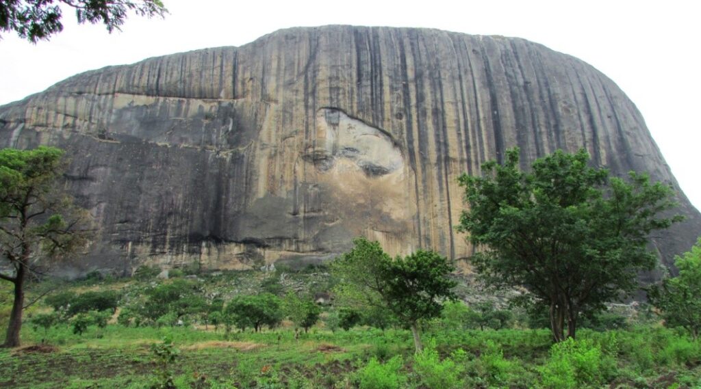
5. ZUMA ROCK
Zuma Rock is a large natural monolith, an igneous intrusion composed of gabbro and granodiorite, in Niger State, Nigeria. It is located immediately west of Nigeria’s capital Abuja, along the main road from Abuja to Kaduna off Madala, and is sometimes referred to as the “Gateway to Abuja from Suleja”. Zuma Rock rises approx. 300 metres (980 ft) above its surroundings.
A rock with facial features
Yes you read right! Zuma Rock has natural contours on the surface which depict the image of a human face with a visible mouth, eyes, and nose. The natives of the community believe the face represents the deity and ancestral powers protecting and governing the affairs of the community. The Gwari people also acknowledge the rock as a gateway for the afterlife; it is believed that when people die, their spirits go to the rock.

The rock catches fire during the rainy season
The rainy season in Nigeria between April and October comes with another myth surrounding Zuma Rock – it is reported that the apex of the rock often catches fire. Natives attest the happenings to the wonders of the deities and voodoo spells. However, scientists object to the belief. Dr. Kistso Ngargbu, a geologist and lecturer at Nasarawa State University,Keffi, notes that:
“If it is after rainfall and a particular boulder or broken pieces of the rock got saturated with water, that’s the contact between heat and the main rock body. In the event that it had to slide because water now serves as a lubricating surface, friction is created. We should remember that our forefathers used to make fire from rocks glided against each other. That is what could have happened. Rain water got to the surface, lubricated the boulder and then generated a sliding probably based on a sloppy surface, and in the event of sliding down the fire came up”.
It served as a hideout against external forces
There is no precise account pertaining to the origin of the rock, however, Zuma Rock is said to have been first located in a thick forest by the people of Zuba in the 15th century upon the instruction of their soothsayer. The Zuba people named the rock, “Zumwa”, which means “the place of catching guineafowls” upon finding out that there were many within the forest. At their arrival in the forest, they settled around it and constructed settlements, and later discovered the spiritual representation of the rock as a powerful deity. They turned to worshipping and offering sacrifices to the rock to protect them and keep them safe from evil. Over time, the people of Gwari used the rock as a defense and hideout against invading neighboring tribes and external forces.
It protects against a disastrous outburst
Another yet interesting myth suggests that the Zuma Rock sits on a very large expanse of underground water. It is believed that if the rock is pulled down, there will be an outburst of water which will submerge an unimaginable land area.
Fun facts
The famous Zuma Rock features on Nigeria’s 100 Naira currency banknote.
It is twice as high as the Uluru Rock in Australia – it is also higher than the height of Nigeria’s popular Aso Rock and Olumo Rock put together, and more than four times as high as Nigeria’s tallest building, NECOM House.
6. OGUTA LAKE
Oguta Lake is a lean ‘Finger Lake’ formed by the damming of the lower Njaba River with alluvium. At 8.05km long and 2.41 km wide, It is the largest natural lake in Imo State, Southeastern Nigeria; within the equatorial rainforest region of Niger Delta. Oguta Lake’s catchment area comprises the drainage area of the Njaba River and a part of the River Niger floodplain in the region south of Onitsha.

In many ways, these wonders, especially those made by nature’s hand, are mysteries, more than anything else.
Like the Northern Lights or Tanzania’s 260 square km wide Ngorongoro crater, they are unexplained phenomena that arouse our curiosity, a desire to know more and questions that we try ever so hard to answer with science or religion.
One of such wonders is hiding in Nigeria, in Imo state, within the rainforests of the Niger-Delta. The lake is situated in Oguta about thirty miles (48.27 km) from the junction of the Ndoni and Orashi River. It is a fine piece of water, being about five miles (8.05 km) long from east to west and a mile and half (2.41 km) wide. The stream from Njaba River is the major inflow to Oguta Lake. The other 3 tributaries are Awbana, Utu and Orashi. The Orashi River flows past Oguta Lake in its southwestern portion.

Locals believe that the two rivers were male and female, man and wife. The green water is Ogbuide, believed to be the female. The brown water is the male, Urashi. The stories claim that they had a quarrel, since then, they have flowed separately.
Nowadays, the two are deities; man and wife have become god and goddess. There are two separate shrines where worshippers invoke and offer supplication to them; one on each side of the river.
The quarrel does not affect places of worship, and worshipers can call on either deity from any of the two shrines. But those liberties do not extend to every area.
Even as it stays hidden in a corner of Imo, Oguta is a major attraction and every year, thousands come to visit, including some who do not understand the efficacy of its legends. Sometimes, the couple is taken for granted and the inexplicable happens.
The lake is important to the people of oil-rich Njaba River basin including Oguta, Orsu, Mgbidi, Nkwesi, Osemotor, nnebukwu,mgbele,Awa Awo-Omamma Akabo as a source of water, fish, tourism and an outlet for sewerage. Uhamiri is the goddess of the Lake.
The river route Njaba and Orashi via Oguta Lake to the coast, passing through Awo-omamma, Mgbidi, Oguta, Ndoni, Abonnema, Degema made Oguta, Osemotor, Awo-omamma and surrounding towns important commercial centres of international trade mainly for oil palm.
Oguta Lake is also home to some relics of more recent times, particularly the 70s when the area was one of the many theaters in the Nigerian civil war.
Not far from the lake, there is what appears to be an abandoned 18-hole golf course. But move closer to the course and you will see it, right there in the bushes; a bunker used by Biafran forces during the civil war.
The lake was also used as a base by the Nigerian Navy during the war. There are reports that remnants of old Biafran war boats can be found in various areas of the lake. Now, as a new generation lives around the lake, the mystery of the two rivers, its history as an important part of the Biafran war and many unanswered questions about its past remain.
They are why Oguta Lake and its immediate environment deserve a facelift if for no reason, to preserve one of the many wonders that Nigeria is so blessed with. Until that happens, Urashi and Ogbuide continue to flow in the same lake, side by side, without ever coming together.
7. EZEAGU FALLS
Located in the southern central part of Enugu State, the Ezeagu Tourist Complex is a half hour drive from the state capital and sits in an area of outstanding natural beauty. The complex features exotic foliage, a beautiful waterfall, a natural spring and lake and a three kilometer long cave full of tunnels and chambers.
Take a thirty minutes’ drive from the bustling capital city of Enugu State to Ezeagu Tourist Complex. The complex exhibits one of the natural wonders of nature. Measuring about 22 hectares in size, it comprises a lake, a cave and a waterfall (spring water). Pilgrims are continuously attracted to this site following the believed curative nature of the water from the fall.
The waterfall, locally called ‘Ogbagada’ is about 23 meters high. The water rushes down the cliff with a thunderous sound that can be heard from a distance.

One great phenomenon about Ogbagada is its associated ability to signal the beginning of harmattan through an unusual loud noise from the falls. Its splendour is expressed by the almost 5 kilometers long Obinofia cave whose sheer size and compartments is awe-striking.
The people of Ezeagu LGA are known popularly for abacha as the most common staple food. They produce it both in subsistence and commercial quantity. Abacha is made from grated cassava that has been cooked before grating. The starch is thereafter washed off and is then processed dry. Ingredients includes dry processed cassava (abacha), palm oil, fish, oil bean (ugba), calabash nutmeg (ehuru), onion, seasoning, salt to taste, potash, garden eggs and garden egg leaves (akwukwo aghara). Abacha is better prepared in local pots popularly called ‘Oku’ than in modern pots.
8. OWU FALLS
This heaven on earth is located in between twins sister communities of Owa Onire and Owa Kajola communities in ifelodun local government area of Kwara State. The existence of Owu falls is untraceable, but the fall has been described as the highest and most spectacular natural waterfalls in West Africa and sometimes referred to as a “wonder in the wilderness’’.

Owu Falls is always at its best during the rainy season which spans 200 meters across making it a wonderful vacation spot. In Owu Falls, you experience a fine mix of awesome attractions and access to top quality accommodation as it offers a range of quality assessed accommodation with good quality restaurants. Its perfect location and memorable vacation experience makes it the perfect destination to host your next vacation.
The water fall is 120m above water level and cascades 330 feet down an escarpment with rocky out crops to a pool of ice cold water below. The water falls is surrounded with a beautiful natural ambience and hills which makes sightseeing a memorable experience. The waterfall is characterized with fall of ice cold water, beautiful rocky part and walk ways, and evergreen surrounding.
This beautiful surrounding is composed of stretch of mountains extending to Ekiti and Kogi States, which makes for an attractive environment to visitors and offers them opportunity to engage in the sighting of other creatures such as like birds, monkeys and reptiles. The natural flora and fauna have turned the falls into a nature seekers delight.
Visitors will enjoy swimming in the pool or just watching others enjoy themselves while taking part in a picnic. It is also possible to check out Owe Kajita waterfall, the Ahoyaya falls in Jebba, and the Ubo Aiyegun Lakes.

9. LA CAMPAGNE BEACH RESORT
La Campagne Tropicana Beach Resort located in Lagos, Nigeria is focused on presenting African hospitality and culture in a cosmopolitan manner. The resort boasts of a clean beach, lagoon and mangrove forest that provide visitors with the opportunity to observe, at close quarters, a wide variety of tropical Flora and fauna that include snake trees, mangroves, various species of epiphytes, monkeys, squirrels, bats, and various species of birds such as kingfishers, sea hawks, egrets and ducks.

Explore the mangrove forest, play, bond with families and team members, go fishing in the lagoon or do nothing but relax sandwiched in between the warm sands on the beach, whatever rocks your boat!. The resort is ideal for honeymoons, corporate retreats and conferences, family getaways, getaways, destination proposals and weddings.
The Resort boast of a 2000 meter of soft, golden sand which stretches between the shades of majestic coconut palms, the warm Atlantic Ocean and the placid lagoon. This offers ample opportunities for water sport activities: Kayaks and Canoes let children skim the lake at their own speed while cruises on the boats can help parents escape for an hour or two. Guests can go on a guided cruise of the lake or just enjoy the resort canoes, floater, paddle boats, tubes, jet skis, swimming bikes, sea scooters and luxury boats. Corporate bodies too can have their conferences and meeting sessions on the boat as it cruises slowly on the placid lagoon. A cruise on boats is now available from Victoria Island to the resort (and vice versa).

The Resort , primarily as result of its reputation for creating African experiences that remain indelible in the minds of tourists, is experiencing tremendous growth and is now establishing branches in Refuge Island ,Lagos, Koton – kafe , Kogi State(45 minutes’ drive from Abuja) and Idanre, Ondo State all of which are in Nigeria and is in the process of establishing a presence in Nejashi, Ethiopia and 18 Locations in Cote d’ivoire including Grand Bassam and Adiake Since inception, La Campagne Tropicana has brought tremendous economic benefits to its host communities and to Nigeria by extension through the provision of jobs that can be efficiently carried out by the individuals in these non-urban communities.

Boosting viable commerce in the community to the mat weavers and craftsmen through the introduction of talking drum as door bells and mats as ceiling. Prior to this introduction, the demand for the local mats was considerably low as it was seen as an object of poverty as a result, mat weaving (and trade passed on from generation to generation) was about going into extinction but with the application of the mat as a more effective and aesthetic ‘asbestos’, this has removed the mat from an object of poverty to prosperity and has helped drive its demand, thus saving a unique ancient trade from extinction. The use of the talking drum as a door bell has increased its demand because more people can now beat the drum as it is no longer a musical instrument meant only for professional ‘ayan’ (drummers).
10. KATAMPE HILLS
Katampe Hill is a rocky outcrop that serves as one of the highest points in the capital and the geographic midpoint of the nation. This naturally hilly topography allows for some of the most beautiful panoramic views of the Federal Capital Territory.

5 essential things you will need when going for hiking
1 What to wear: This shouldn’t be a problem you can wear whatever makes you feel comfortable I have seen people wearing shorts when hiking.
2 Footwear: Your footwear could be hiking boots or sneakers you wouldn’t want to hike with a flip flop because it will be slippery and you are likely to fall which is dangerous so i recommend you get hiking boot or sneakers to be on the safer side
3 Water Bottle: Make sure to take enough water with you when hiking, you will need to stay hydrated so water is very important when going on hiking
4 Food: depends on how long you plan of staying on the hill if you plan on staying longer or you plan on going on a picnic then I would recommend you go with food or at least snacks…food is optional when going hiking.
5 First aid kit: You will need a first aid kit in case you sustain an injury while climbing the hill to be on the safer side make sure to add a first aid kit on your list
Remember to go with friends when going on hiking it motivates you and it is fun with friends take caution when climbing the hill….you can share your hiking experience in the comment section below thank you


